Spatial analysis
for climate adaptation.

GIS consulting for international development and adaptation planning.

MSc Geography — Climate Science Lab

BSc Environmental Science and Management — Climate Change focus

What I Do

Geospatial expertise applied to climate adaptation — from hazard mapping to institutional capacity, grounded in field context.

I.

Climate Vulnerability Mapping

Extreme weather is getting worse. Some are hit harder than others. I map those geographic disparities using a composite of vulnerability indices. By layering climate hazard with social factors (income, access to services, infrastructure), the analysis reveals not just where risk exists, but who is most exposed. My multi-hazard spatial analysis utilizes CMIP6 projections, open source administrative datasets, and community input for localized and scaled assessments.

II.

Remote Sensing for Adaptation

Communities are already retreating from sea level rise. Prolonged drought is forcing farmers to uproot entirely. Over a billion people worldwide live in informal settlements that are particularly vulnerable to the effects of climate change. Climate mitigation is no longer the sole necessity. Adaptation is paramount and remote sensing can help. I use Sentinel, Landsat and Earth Engine to understand and communicate realities on the ground.

III.

GIS Capacity Building

While most of the time you'll find me behind the computer screen, my true passion is talking to people. Giving people the tools to perform these analyses will help them strengthen their communities. I have conducted trainings to build GIS capacity both remotely and in person on five continents. From data management and spatial workflows to monitoring and evaluation using GIS tools.

Past Engagements

A selection of projects across climate adaptation, development, and conservation.

Climate Analysis & Remote Sensing 2025

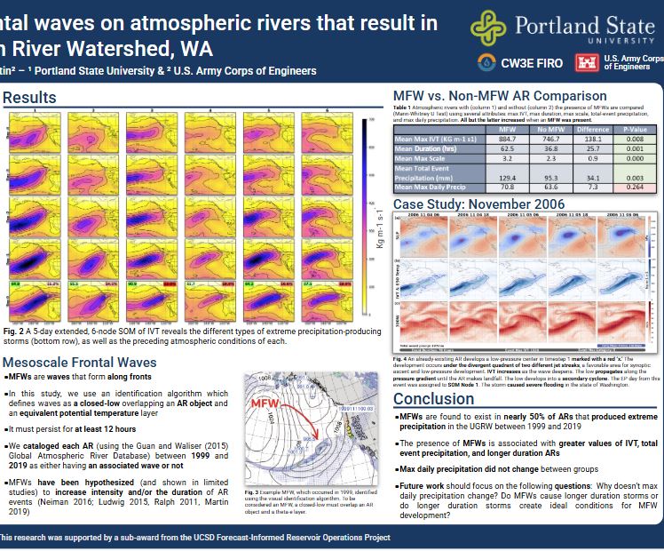
Mesoscale Frontal Wave Analysis — Measuring Impact

Analyzed the effects of mesoscale frontal waves on North Pacific storms using NASA MERRA2 data, finding a statistically significant increase in storm duration and intensity. First author in partnership with Portland State University and the Center for Western Weather and Water Extremes, funded by the U.S. Army Corps of Engineers.

Mesoscale Frontal Wave Analysis
Vulnerability Mapping 2024

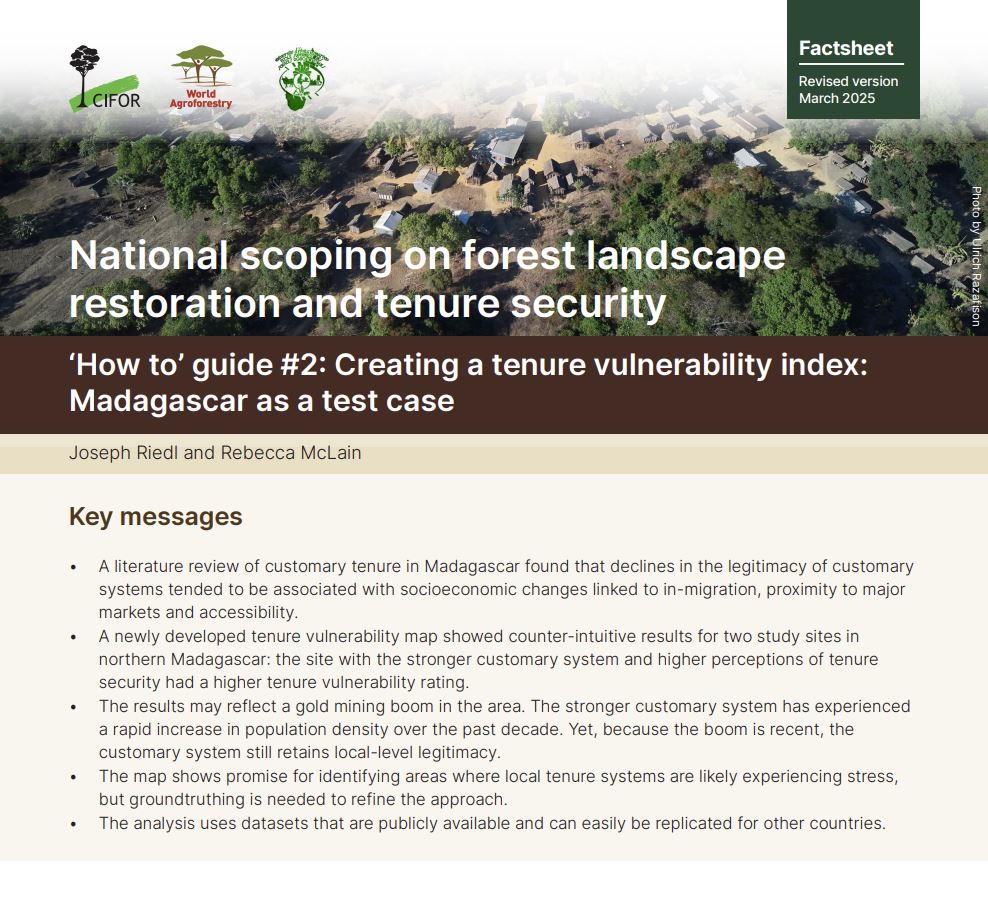
Madagascar — Layered Land Tenure Vulnerability Analysis

Combined on-the-ground fieldwork in remote regions of Madagascar with technical expertise to conduct a countrywide, high-resolution geospatial risk analysis. Built a methodological workflow to replicate the analysis in other countries throughout Africa. First author on a fact sheet for CIFOR–ICRAF with funding support from GIZ.

Madagascar Land Tenure Vulnerability Analysis
Capacity Building 2024

Kenya & Global — Multilayered Vulnerability Assessment and GIS Workshops

Non-author contributor to UN-Habitat's Multilayered Vulnerability Analysis Handbook. Assisted with implementation of the analysis with country offices on three continents. Delivered supplemental workshops on GIS and spatial analysis.

Multilayered Vulnerability Assessment and GIS Workshops

Recent Work

A selection of recently published maps across climate, energy, and geopolitics.

SSP Trends SSP Trend Analysis — which future are we trending toward?
A snow-drought sweeps through the U.S. West
A snow-drought sweeps through the U.S. West Python, NRCS AWDB API
Precipitation in the continental U.S., Dec 2025
Precipitation in the continental U.S., Dec 2025 NOAA PRISM, Python
Reported deaths associated with heavy rain events, Nov 2025
Reported deaths from heavy rain events, SE & S Asia, Nov 2025 ACLED event data, ArcGIS Pro
The Greenland Strategy
The Greenland Strategy Natural Earth, ArcGIS Pro
JNIM Expansion, 2022–2025
JNIM Expansion, 2022–2025 ACLED conflict data, ArcGIS Pro
Cross-border Attacks, Oct–Dec 2025
Cross-border Attacks, Oct–Dec 2025 ACLED conflict data, ArcGIS Pro
U.S. Gas Power Plants by Watt Capacity
U.S. Gas Power Plants by Watt Capacity EIA plant data, ArcGIS Pro
Natural Gas Proven Reserves, Global
Natural Gas Proven Reserves, Global BP Statistical Review, ArcGIS Pro

Experience and Organizational Clients

United Nations CIFOR USGS US Army Corps of Engineers NPCC CW3E Portland State University AmeriCorps Peace Corps

Get in touch

Working on a climate adaptation program that needs spatial analysis or GIS support? I’d like to hear about it.